THE WONDERLAND TRAIL 2023 - Circumnavigation of Mount Rainier, Washington

I won the lottery! The lottery for early application for a wilderness permit for the Wonderland trail, that is. The Wonderland Trail is a world-famous trek of approximately 93 miles around Mount Rainier in Washington state. It offers different microenvironments, significant elevation changes every day, the challenges of alpine environments, and opportunities for spectacular scenery and wildlife. It is also tremendously difficult to get permits. So I was super excited to have obtained early access for a permit: backpacking the Wonderland Trail has been on my bucket list for more than 8 years! I did this trek in mid-September, after much planning and anticipation. Permit challenges meant the trip was longer than I would have liked; on the other hand, I would still have time for photography and enjoying the views in spite of the significant elevation changes each day.

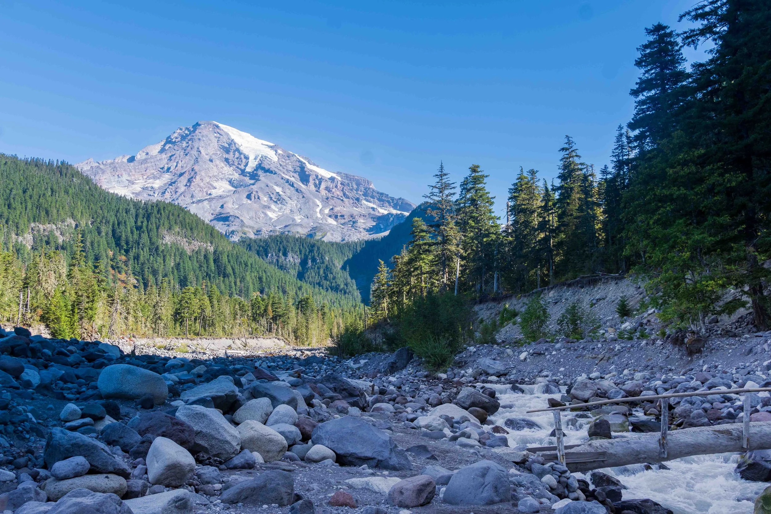
Mount Rainier in Washington State
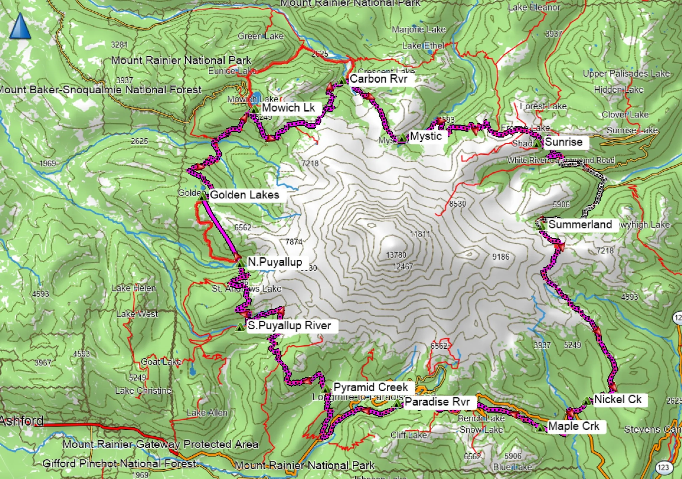
GPS Track of Route and campsites

GPS Elevation Profile
Permit Challenges: I read up on all the options of trailhead starting locations, cache locations, and routes (clockwise, counter-clockwise) in advance, and had printed up 23 pages of possible itineraries in advance of the moment my lottery window opened in April (toward the end of the early access season). It turned out to be challenging indeed, but I was able to secure a route, albeit much longer than I desired (12.5 days instead of 10-11) and with an imbalance in mileage because campsites were full. For example, I had a 13.1 mile day followed by a 2.6 mile day! Nevertheless, I was thrilled to get the permit I had, and hoped I could make some adjustments by arriving the day before my trip. I also planned an “extra” night with a short hike out on my last day, so I could start the long drive home earlier in the day. I always prefer a night in the wilderness to a night in a hotel. See below in Logistics for permit suggestions that may not already be covered by the park website, valuable trail guides, or Recreation.gov. During my planning, I had telephoned the ranger at Mowich Lake, who told me that there had been occasional thefts of food caches at the unmanned storage locker at Mowich lake, and “you should be able to carry 10 days worth of food in your backpack anyway.” I was disappointed in his cavalier attitude; it is a lot easier for a 190+ lb man to make that claim than a <120 lb. female. I was not going to carry 12 days of food, but as I didn’t want to abandon my trip due to a food shortage, I opted to carry 8 days of food out of an abundance of caution. It made for a heavier than usual pack for a few days of the trip. My route was to start at White River, and hike clockwise, with only one food cache at the Longmire Wilderness Information Center. I did this trek in mid-September, which I felt was a great time to experience the park. As I was in town a day early, I opted to drop the cache and extra fuel canister off at the WIC, rather than mailing it in advance.
Pre-trip Challenges: I opted to camp the night before at the White River Campsite, which is first-come, first-served with no reservations. The campsite, and the weather, were pleasant. Rather than unpacking my tent and gear, I opted to sleep in my car for the night. But around 10 p.m., I heard a skittering, scratching sound. I sat up, thinking perhaps a mouse was running across the roof. I listened carefully, no, it was a mouse IN THE CAR! Aargh! I got out and shone my headlight under a seat, where a pair of small, beady eyes stared back at me. I was not comfortable sleeping with a mouse running back and forth inside the car, over my sleeping bag. Yet I couldn’t think of an easy way to eject him from the car. With a few curses, I got up and set up my tent with my headlamp, so I could at least avoid dealing with the mouse. I had my food inside a bear can in the car, so at least the mouse could not chew on my food.
I managed to get some sleep and packed up for the trailhead in the morning. At the trailhead, I told the story to a ranger, who said “Yeah, that’s a big problem here.” Apparently the mice have figured out that the cars are nice and warm and full of food; as smart as a habituated bear! I had no time to do anything to protect my car during its 12 days at the trailhead, so I made sure there was no residual food anywhere, locked everything up and hoped for the best as I departed, headed for Summerland. While I resolved to research options for rodent-proofing my car in the future, for now backpacking the Wonderland Trail was the highest priority!
Day 1: White River Trailhead to Summerland: 7.0 miles* / 11.2 km
I started the trek around 8:30 a.m., under cool grey skies that had me wearing a fleece for the first 2 hours. The hike was quite easy, and I took a bit of time to stop for photos and enjoy the scenery. Only during the last few miles or so did the trail climb as I ascended to the beautiful Summerland camp, just after lunchtime. I found a nice site with privacy, which was just being vacated by a couple getting a late start for their day. I was happy to be able to hang my food using the supplied pole and hanging tool, rather than carrying a heavy bear canister. Such an improved system; I wish they used this in California Parks. I delightedly watched two marmots chasing each other as I gathered and filtered water.


From camp I could get occasional views of Mount Rainier’s glaciers through the clouds, and a peek at the next day’s route south over higher elevation to the Indian Bar area. The White River flowed far below, and I hadn’t realized I had climbed to ~6000 ft elevation.
Day 2: Summerland to Nickel Creek: 11.5 miles / 18 km
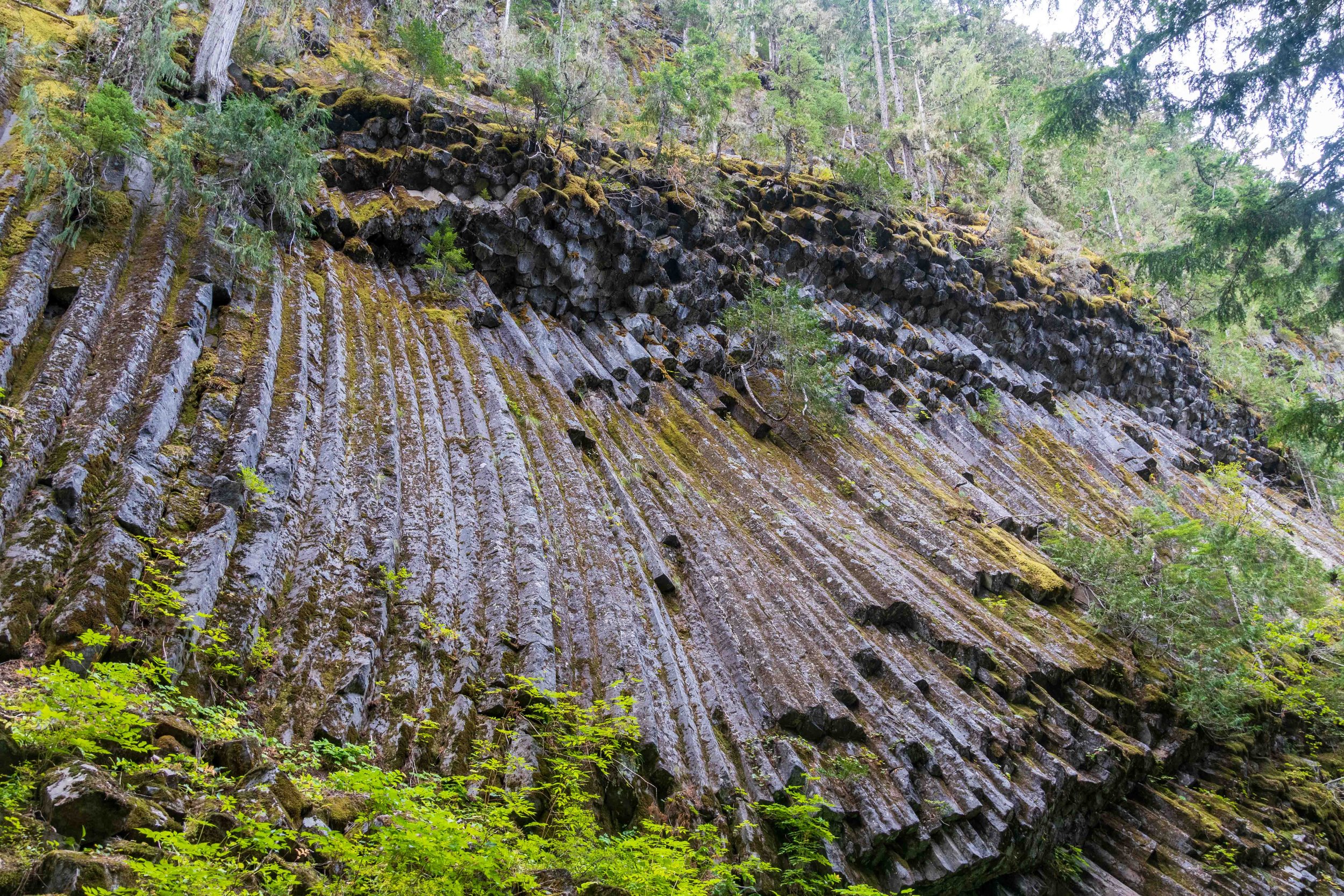
What a fabulous day of hiking! The day began with an ethereal hike above the treeline, through fog and mist at the pass at Panhandle gap, followed by a descent into beautiful Indian Bar. The beauty of this “floating meadow” hidden away from civilization is hard to describe. I could see why it was such a treasured location for the indigenous people and early settlers. I stopped for lunch at Indian Bar, filtered water in the stream, and wished I could have scored a campsite here as part of my itinerary. But this is perhaps the most sought-after site on the trail, and I reluctantly moved on for a bit more climbing to the Cowlitz Divide, before the long overall descent to the Nickel Creek campsite. The change in microenvironments and geological features throughout the day was fascinating.

SLIDESHOW


Day 3-4: Nickel Creek to Maple Creek to Paradise River: 10.9 miles* / 17.5 km
In selecting campsites to secure a complete through-hike of the Wonderland Trail, I was unable to secure Paradise River on my desired date after Nickel Creek, so I had to settle for a frustrating extra short day from Nickel Creek to Maple Creek to make things work. And trying to change this with the ranger just before my hike would have jeopardized all my subsequent campsite reservations. I figured a short day to slow down and take it easy wouldn’t kill me, although I was frustrated at having to carry the extra food. Just having a complete permit felt like cause for celebration. These were very easy days, at lower elevation and through picturesque forests, meadows and streams.

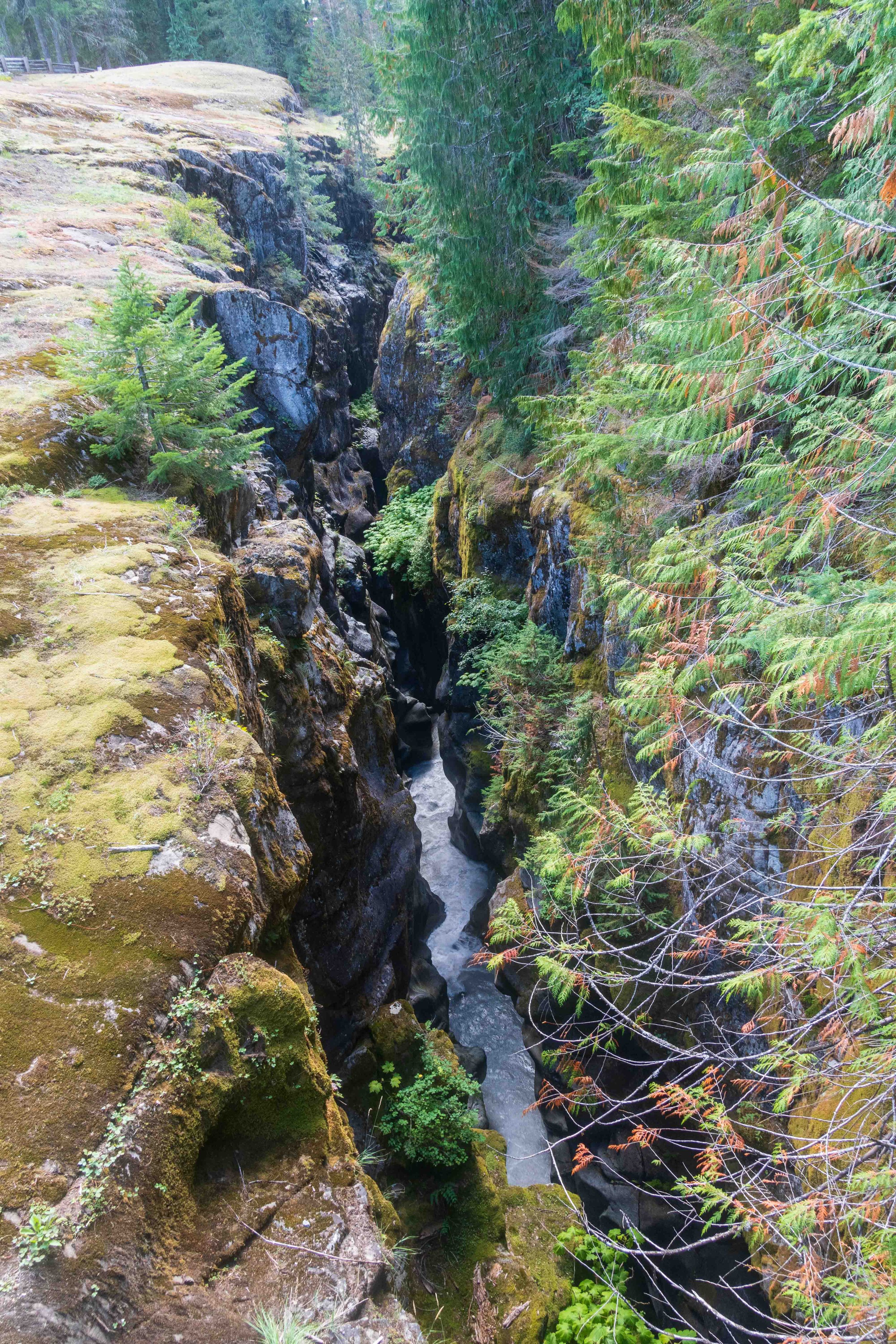
I stopped at Box Canyon to photograph the amazing deep gorge: up to 180 feet deep yet only 13-30 feet wide at its narrowest point! Road crews were working on Stevens Canyon Road, which was closed to through traffic on weekdays.

The very nice and helpful rangers at the Longmire WIC had warned me of a recent slide that damaged the trail between Maple Creek and Snow Lake, and a couple I met near Nickel Creek who were hiking counter-clockwise warned me as well. The woman said she found it extremely scary, and was near tears after crossing it. But there was no option to avoid it, other than quitting. I found the spot about 2.4 miles after Maple Creek, and it was indeed a very narrow “trail” overlooking a steep slide down a canyon wall. I went slowly and with measured steps, and found it unnerving but manageable. As an older, solo hiker, I’m always cautious, and sometimes subject to ‘imagining the worst’.


I stopped several times to take photos of waterfalls, and stopped for lunch at gorgeous Lake Louise. The weather was perfect, sunny and not too warm. Near the road, I saw a few tourists at Reflection Lake, where I also lingered a bit to enjoy the scenery and the beautiful day. From there, it was mostly downhill to Narada Falls and then the campsite at Paradise River.


Day 5: Paradise River to Longmire WIC to Pyramid Creek: 7.2 miles* / 11.5 km
I had a leisurely hike from the Paradise River camp, starting around 8:30 am in a cool morning. I spent a bit of time at Carter Falls, taking long-exposure photos, before hiking more quickly downhall in an easy trail to the Longmire WIC. There, it was a nice break to wash up, charge my Kindle device, pick up my extra fuel canister and heavy food cache for the remainder of the trip, and drop off a couple un-needed items and some trash. The rangers were quite friendly and helpful. It was another beautiful day, and the forecast for the rest of the trip was favorable, with just a chance of showers for a couple days - lucky me! I didn’t spend long at the WIC, but shouldered my now much heavier pack with 8 days worth of food, and headed uphill to Paradise Creek camp. The climb up Rampart Ridge was fairly steep, at ~700 feet/mile, and the hot afternoon sun had me soaked with perspiration. Beyond Rampart Ridge, the trail leveled off, and I took note of some significant landslides that had occurred recently.


Day 6-7: Pyramid Creek to South Puyallup to North Puyallup: 7.2 miles* + 6.7 miles / 11.6 km + 10.8 km
This day sticks in my memory as one of the more tiring of the trip. The mileage wasn’t that high, but the hike from Pyramid Creek to S. Puyallup River involved two ascents and descents of over 1400 and 1600 feet, and it was a very hot day. The scenery was gorgeous and the Tahoma Creek Suspension Bridge was worth a stop for photos. Over 100 feet long and more than 200 feet high, it prompts one (yes, only one at a time!) to tread carefully as it swings during the trek across. Evidence of past lahars reveals the power of these events, as they cut deep swaths through the landscape. The climb up Emerald Ridge went from verdant green to subalpine rocky terrain, and in the hot sun it did feel a bit long. Once at the top, I stopped to photograph a very sociable marmot, who came galumphing over to visit me when I stopped on the hillside. On the descent from Emerald Ridge, there is one section of the trail (discussed in the guidebook) that was quite sketchy, with crumbling edges above a steep and rocky hillside. Most of the descent was loose rocks and rocky uneven footing, which made me all the more grateful to finally reach the forested area as I approached the S. Puyallup river camp.


I found water at S. Puyallup by contining on the Wonderland Trail just a bit further than the camp, at the third little bridge after camp. Also, the campsite was closer than the icon marked on many maps (see the GPX file of campsite waypoints below).
The next morning brought cooler mackerel skies, making the climb to Klapatche park more pleasant. As advised by the rangers, I filled up on water at St. Andrews, as Aurora Lake was completely dry. The views at Klapatche were fantastic though, so I stopped for lunch. The descent to N. Puyallup River was forested with plenty of shade, and lots of switchbacks. The campsites were not great though; three sites were lined up next to each other on an old dirt road with minimal privacy between sites.


Day 8-9: North Puyallup to Golden Lakes to Mowich Lake: 5.1 miles* + 10.2 miles / 8.2 km + 16.4 km
There was light rain during the night, and enough sprinkles continued for me to don my rain gear for the short hike up to Golden Lakes. This was another couple of days where I was stuck with uneven mileage due to campsite shortages on specific days. Although there were plenty of berry bushes (huckleberry? blueberry?), there were few if any berries left this late in the season. Hopefully most of them went to the bears. A kind ranger showed up on the trail after hanging a warning sign for a yellowjacket nest further along the trail. Thinking I could just power through the trail, I neglected to put on my headnet. Fortunately, I only got stung once. Golden Lakes offered a beautiful campsite, with nice views to the south and peaceful lakes.

My GPS battery died between N. Puyallup and Golden Lakes, so that track is not included here.


The next morning’s hike brought a long descent to the South Mowich River, and fortunately a bridge was in place. Bridges over this river frequently don’t survive each year, and I was happy not to have to wade across that cold rushing water. The day was cool and cloudy, and I gathered more water at a small creek (not the silty river) that I had noted from the guidebook, before the ~2400 foot climb all the way back to the higher elevation at Mowich Lake. The campsite at Mowich was more civilized, with marked tent areas, picnic tables and enclosed vault toilets. But it was nevertheless a gravel parking lot, so just couldn’t match the beauty of the wilderness campsites. Water had to be collected from the lake, across from the unoccupied ranger’s cabin. Although I had no food there, I checked out the food storage area, and it was indeed open for folks to sort through. During the trip, some I spoke to seemed surprised that I was told there were thefts there, but one or two agreed that incidence was “not zero,” especially since the camping area was open to outside traffic. All the cache sites had a “hungry hiker” bin of discarded food packages (often hikers bring too much food), so it would seem unnecessary to steal someone’s cache.
I was looking forward to hiking the north side now, with just a few days remaining of the trip.

South Mowich River crossing
Day 10-11: Mowich Lake through Spray Park to Carbon River to Mystic Camp: 8.5 miles* + 5.0 miles / 13.7 km + 8.0 km
There was a light but steady rain in the morning, which seemed to make packing up require more time. It was also very cold and quite foggy, so I skipped the views at Eagle’s Roost, and stopped only briefly at Spray Park, as it was impossible to get good photos in the rain and fog. The rain stopped around noon and the sky cleared somewhat, until I reached the pinnacle above the treeline, where the snow, rocky terrain and fog created an eerie landscape. There were no other hikers around, so I felt as if I had the mountaintop to myself as I stopped for lunch. Before the descent, the trail was difficult to follow, and I was glad I had my GPS in the foggy conditions. Hiking here was otherworldly, and fantastic!

SLIDESHOW


After being alone on the more forbidding higher elevations, I was happy to be descending to the treeline, where it felt warmer. I arrived later than usual at the Carbon River camp, with just enough time for camp chores and dinner. It was quite a bit colder than any previous nights of the trip, and I decided to sleep in for my short-mileage day to Mystic Camp.
In the morning, I couldn’t resist taking some photos of the very impressive Carbon River suspension bridge, which must have been a challenge to build! The views just kept improving on the uphill climb to Mystic Lake, providing some of the best views of Mount Rainier of the entire trip. Mystic Lake was a beautiful campsite, and I took some time to enjoy the warm sunshine, before returning to my tent site under the forest cover. That night was the coldest of the trip, and I put on my down jacket when I awoke in the early morning hours, then climbed back into my down sleeping bag.


End of Trip: Mystic Camp to Sunrise Camp to White River Trailhead: 8.7 miles* + 3.4 miles / 14 km + 5.5 km
Brrr, chilly in the morning and I set off with all my layers on. I stopped several times for photos, and by the time I began the climb to Dick’s Creek all my extra layers were off. So nice having a lighter pack with most of my food gone! When I stopped for water at Granite Creek I was warned of a bear, but I never saw it. It was perfect weather on my last full day on the trail, with blue skies, a bright sun, and puffy white clouds. The views were just spectacular at the top of the climb, and I stopped to have lunch and marvel at the views before the long, sloped downhill to Sunrise Camp.

SLIDESHOW


As the Sunrise camp is a short hike in from the road, it was more populated with typical weekend campers. The forecast on my last day was for rain and snow, but fortunately I made it out early the next morning before it all began. It then rained for several days afterward, and I felt very lucky with my timing! The final 3.6 miles out to the trailhead was nearly all dowhill, and went quickly. It was quite a bit cooler and more overcast than when I began the trip, but I felt exhilarated at having completed it, and sorry to leave behind this fantastic national park.
This was my first multi-day backpacking trip longer than 6 days that involved food caches, and I thoroughly enjoyed it! I would have preferred a shorter trip, but I was thrilled to get a complete permit at a favorable time of year. The changes in elevation were not as challenging as I expected, even with extra food for a few days. I especially loved the experience of seeing the mountain from so many different angles, and trekking through such diverse landscapes with spectacular scenery around every corner. Truly the experience of a lifetime! I higly recommend this trip.
Photos by Cris Lewis: Sony alpha 6600, 18-135 mm Sony lens
* Mileages are official miles between campsites as published by the National Park Service in 2023, not GPS-captured mileage.
LOGISTICS
The best guidebook to prepare for this trek is “Hiking the Wonderland Trail” by Tami Asars, and I won’t bother to repeat any guidance that is not already included in the book, or on the National Park Service website for Mount Rainier and the Wonderland Trail. Asars, Tami (2012). Hiking the Wonderland Trail: The Complete Guide to Mount Rainier’s Permier Trail Mountaineers Books. ISBN: 978-1-59485-654-9.
This itinerary planner link is very helpful for planning distances around the park for either clockwise or counter-clockwise treks.
For trip planning, I ultimately found that what was the most efficient for trying to register for campsites in the sometimes frenetic moments when the reservation window opens, was not to have numerous printed itineraries, (although these can be helpful) but rather an excel sheet that lists the distance between all the campsites. That way one can start at the desired starting point and quickly register for open sites of appropriate distances, while being able to quickly see what sites might have distances that are too far or too short. Registration at each campsite is sequential, with a limit of 15 miles, and new sites open up on the screen as sites are registered. This software feature makes it difficult to reserve a treasured campsite (like Indian Bar) on a specific date, without having the rest of the itinerary in place. Nevertheless, it is probably the most fair and practical system.
The most popular camps are Summerland and Indian Bar on the E side, particularly because these are accessed by overnight and weekend backpackers. It is suggested to allow extra time between Indian Bar and Nickel Creek, if possible, to sightsee. Similarly, it is suggested to allow extra time between Longmire and Mowich Lake as the elevation changes are significant.
I prepared a document with mileages and altitude changes between peaks, from which I calculated feet / mile for certain legs. That exercise suggested to me that hiking clockwise provided less of a challenge than hiking counter-clockwise. For those younger and/or more fit than I, it may not make a significant difference.
This table was copied from the internet to prepare a handy resource for campsite specifications.
The campsites at Nickel Creek and S. Puyallup River (and perhaps others) are different from their locations on AllTrails and/or GaiaGPS maps. Feel free to download this GPX file marked for campsites, features, and water locations.
Campsites at White River are first-come first served. If campsites are full, camping may be available at other sites in the park or at Silver Springs Campsite for pre- or post-trip staging.
Research after the trip revealed that many modern cars (especially RAV4 SUV’s) have open exhaust vents on their cabin air filters, which enables rodents to easily gain access to the car’s interior. There doesn’t seem to be an easy solution that won’t void a warranty, but an internet search reveals some have resolved their issue by spraying pepppermint oil in that area and in the car’s interior as a repellant, or by attaching hardward cloth (steel mesh) over the air filter port. I am uncertain whether peppermint oil is a bear attractant or repellant, so proceed with caution!